Nuevo artículo: Intra-urban consumption flows and sociospatial disparities: An analysis based on bank card transaction data | Environment and Planning B
El CSIC y el tGIS presentan resultado sobre las movilidad por compras en Madrid y la identificación zonas funcionales por estos flujos usando datos de transacciones por tarjetas
4 feb 2026 - 19:26 CET
Autores: Julia de las Obras-Loscertales, Juan Carlos García-Palomares, Diego Ramiro-Fariñas, María Soledad Herández Martín-Caro, y Javier Gutiérrez Puebla.
Resumen / Abstract
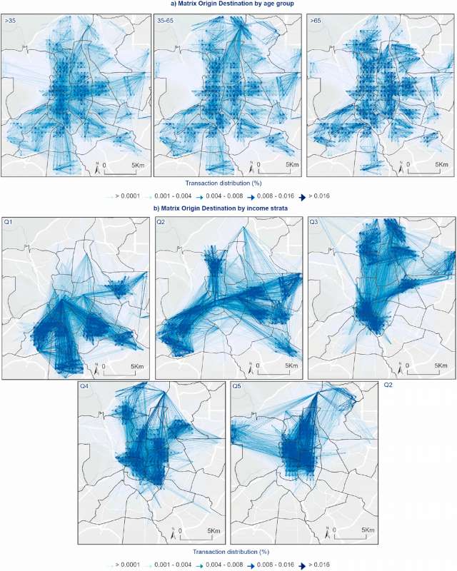
This study analyses intra-urban consumption flows in Madrid through a spatial analysis using over 689 million anonymized bank card transactions recorded in 2023. By disaggregating data by age and income groups, the research uncovers significant variations in consumer mobility patterns and spatial preferences. Older adults and high-income groups exhibit more localized consumption behaviors, while middle-income groups demonstrate wider mobility across the city. High-income populations concentrate their activity in affluent areas, whereas central districts emerge as common ground with higher levels of social interaction. The study applies network and centrality analysis to identify functional commercial areas and their degree of connectivity, revealing strong links between sociodemographic structure and urban spatial dynamics. Results underscore the relevance of integrating consumption-related mobility into urban planning frameworks to address spatial segregation and promote social mix. The research contributes to a growing body of work leveraging Big Data to understand complex urban behaviors at a granular scale.
Enlace: https://journals.sagepub.com/doi/10.1177/23998083261420309
Idioma: Inglés
¿Cómo citarlo? de las Obras-Loscertales, J., García-Palomares, J.C., Ramiro-Fariñas, D., Hernández Martín-Caro, M.S., and Gutiérrez, J. (2026). Intra-urban consumption flows and sociospatial disparities: An analysis based on bank card transaction data. Environment and Planning B: Urban Analytics and City Science