Nuevo artículo: Uncovering spatiotemporal micromobility patterns through the lens of space–time cubes and GIS tools
Daniela Arias-Molinares, Juan Carlos García-Palomares, Gustavo Romanillos y Javier Gutiérrez integrantes del equipo de TGIS firman este artículo de la revista Journal of Geographical Systems
15 jun 2023 - 09:55 CET
Abstract
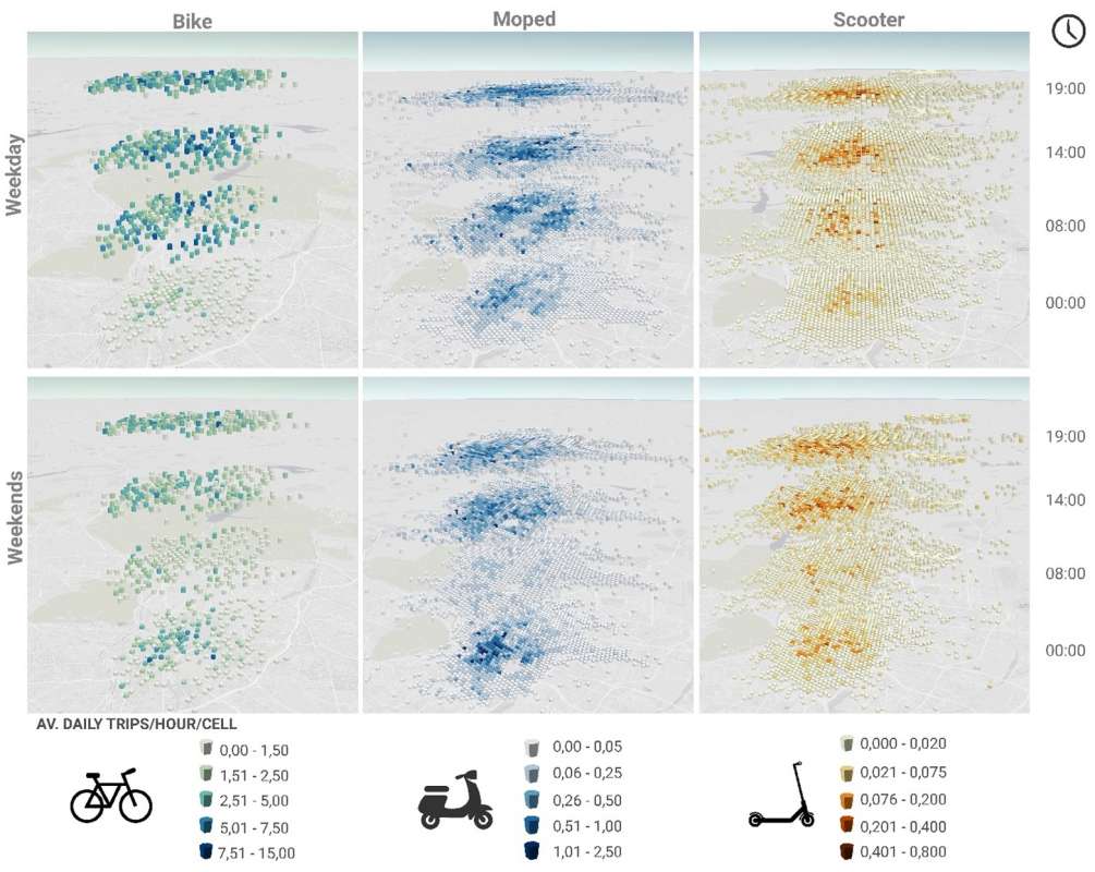
In the past ten years, cities have experienced a burst of micromobility services as they offer a flexible transport option that allows users to cover short trips or the first/last mile of longer trips. Despite their potential impacts on mobility and the fact that they offer a cleaner, more environmentally friendly alternative to private cars, few efforts have been devoted to studying patterns of use. In this paper we introduce new ways of visualizing and understanding spatiotemporal patterns of micromobility in Madrid based on the conceptual framework of Time-Geography. Hägerstrand s perspectives are taken and adapted to analyze data regarding use of micromobility, considering each trip departure location (origins) obtained from GPS records. The datasets are collected by three of the most important micromobility operators in the city. Trip origins (points) are processed and visualized using space–time cubes and then spatially analyzed in a GIS environment. The results of this analysis help to identify the landscape of micromobility in the city, detecting hotspot areas and location clusters that share similar behavior throughout space and time in terms of micromobility departures. The methods presented can have application in other cities and could offer insights for transport planners and micromobility operators to better inform urban planning and transportation policy. Additionally, the information could help operators to optimize vehicle redistribution and maintenance/recharging tasks, reducing congestion and increasing efficiency.
Accede en: enlace