Nuevo artículo: Simulating large-scale urban land-use patterns and dynamics using the U-Net deep learning architecture
Richard J. Hewitt integrante de tGIS firma este artículo en la revista Computers, Environment and Urban Systems
14 nov 2022 - 08:44 CET
Abstract
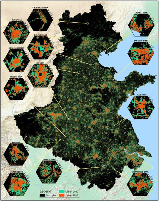
Accurate predictions of land use change are important for supporting planning. Cellular automata (CA) models are widely used to simulate realworld urban land use change but accurately modeling complex spatial urban patterns and dynamics can be challenging due to the high degree of subjectivity involved in CA model parameterisation. Advances in deep learning enable complex spatial patterns such as urban development to be learned and simulated. In this study, we used the UNet deep learning algorithm to capture historical urban development and simulate future patterns for the North China Plain, one of the most rapidly urbanizing regions on the planet. We validated the model against a reference map for 2018 then applied it in predicting patterns of urban expansion for 2030. The results showed that UNet can accurately predict urban land-use and mimic realworld spatial patterns with very low requirement for model parameterization and forcing data. Visual inspection of the outputs revealed that UNet was able to automatically learn complex urban development patterns and processes such as neighborhood influence, the gravity effects of large cities, and the tendency for linear development. Deep learning architectures such as U-Net provide a new parameter-free way to accurately capture and simulate spatial features in projections of future urban development and land use change.
Disponible en: https://www.sciencedirect.com/science/article/pii/S0198971522000990