Nuevo artículo: Modeling Pedestrian Flows: Agent-Based Simulations of Pedestrian Activity for Land Use Distributions in Urban Developments
José Carpio Pinedo integrante del equipo de TGIS firma este artículo de la revista Sustainability
11 nov 2021 - 12:38 CET
Disponible en: https://www.mdpi.com/2071-1050/13/16/9268
Abstract:
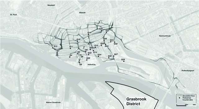
Pedestrian activity is a cornerstone for urban sustainability, with key implications for the environment, public health, social cohesion, and the local economy. Therefore, city planners, urban designers, and decision-makers require tools to predict pedestrian mobility and assess the walkability of existing or planned urban environments. For this purpose, diverse approaches have been used to analyze different inputs such as the street network configuration, density, land use mix, and the location of certain amenities. This paper focuses on the location of urban amenities as key elements for pedestrian flow prediction, and, therefore, for the success of public spaces in terms of the social life of city neighborhoods. Using agent-based modeling (ABM) and land use floor space data, this study builds a pedestrian flow model, which is applied to both existing and planned areas in the inner city of Hamburg, Germany. The pedestrian flows predicted in the planned area inform the ongoing design and planning process. The flows simulated in the existing area are compared against real-world pedestrian activity data for external validation to report the model accuracy. The results show that pedestrian flow intensity correlates to the density and diversity of amenities, among other KPIs. These correlations validate our approach and also quantify it with measurable indicators.