Nuevo artículo:Accessibility Indicators for the Geographical Assessment of Transport Planning in a Latin American Metropolitan Area
Ana Condeço-Melhorado integrante del equipo de TGIS firman este artículo de la revista Geographies
9 sep 2021 - 09:33 CET
Dosponible en: https://www.mdpi.com/2673-7086/1/2/8
Abstract
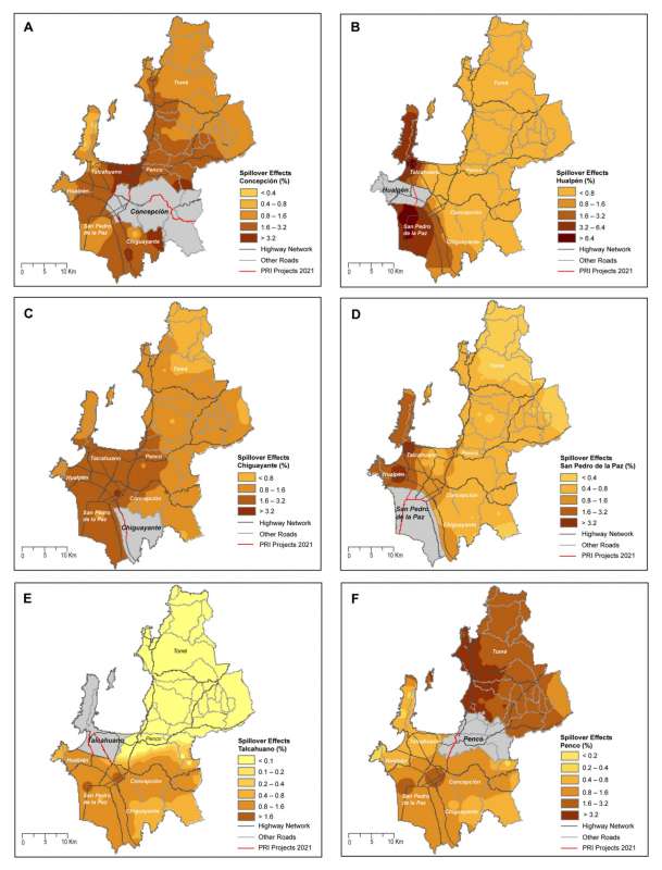
Accessibility represents a key element in strengthening developed regions in terms of investment in transportation infrastructure. Accessibility is also an equity indicator to measure the ease with which a specific location achieves desired outcomes as well as the spillover effect; traditionally, these effects have been analyzed with econometric and engineering techniques, rather than from the perspective of geographical studies. The purpose of this research is to measure the spillover effects and the territorial cohesion of Infrastructure Regional Planning (PRI) for the Latin American metropolitan area of Concepción (MAC), Chile. To meet this purpose, locational and network efficiency indicators of spatial accessibility were calculated using network analysis in GIS. The results showed that the improvements differ according to the accessibility indicator employed; however, they generally showed benefits in consolidated urban centers and corridors near investment and industrial areas. In contrast, more distant and rural areas presented limited and irregular benefits.