NON- DESTRUCTIVE RESEARCH TECHNIQUES APPLIED TO ARCHEOLOGY, HERITAGE, GEOLOGICAL PROCESSES AND CIVIL WORKS
|
Description |
a) Multichannel Ground Penetrating Radar (GPR) that offers sections (radargrams) and 3D blocks to detect buried structures. Applications: Documentation of non-visible structures on archaeological sites, monuments and walls of buildings; detection of infrastructures of civil works (pipes, electric conduits) or buried natural elements.
b) Aerial images from Dron, with legal conditions totally covered. The applications are multiple, from photographic images or conventional videos, to highly accurate photogrametries that allow the generation of digital elevation models (DEM). It also has a camera for obtaining multispectral images. The fields of interest focus on documenting landscapes, monuments and archaeological sites, as well as evaluating erosion and other environmental objectives.
c) Centimeter precision Topography with differential GPS. Generation of cartographies in archaeological sites, location of excavations areas and georeferencing of the information obtained by Georradar and Dron.
d) 3D Scanner for medium and small size objects, reproducible at any scale using a 3Dprinter. Applicable to archaeological/paleontological material withinresearch, museographic collections and public centers.
All these innovative procedures allow obtaining a powerful documentation in processes of investigation and Heritage management without affecting the object on study. Likewise, it offers powerful tools to fields such as civil works, architecture or the environmental studies.
|
How does it work |

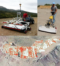
Multi-channel Ground Penetrating Radar Stream X with antennas of 200 and 600 MHz. Detection of underground structures in El Castillón (Ciudad Real).
Ground Penetrating Radar 3D: The technique of georadar prospecting allows to determine indirectly the structure of the subsoil by the transmission of electromagnetic impulses and the subsequent reception of the reflections generated by discontinuities present in the subsoil. In physical terms, the technique is sensitive to all variations in conductivity, electrical permittivity and magnetic permeability that can occur in a medium, whether due to lithological changes or the presence of buried structures.
A geo-computer comprises a data control, storage and display unit connected to an antenna which emits and receives the electromagnetic signal as it travels along a pre-set direction. The technique consists of the transmission in the subsoil of electromagnetic pulses of short duration (1-4 ns) and high frequency that propagate in depth with a certain speed. Depending on the frequency used it is possible to obtain results of greater or lesser depth and higher or lower resolution. The equipment of the CAI of Archaeometry consists of two 200 and 600 MHz DML antennas. The first consists of 16 V dipoles at 12 cm apart which gives it a sweep width of 1.8 meters. It is carried in a stabilizing crane that allows it to work in rough terrain and can be dragged by a conventional vehicle or by a Quad, to reach areas with low accessibility. The 600 MHz antenna has 12 V dipoles at a spacing of 8 cm which gives it a sweep width of 0.88 meters and reaches a higher resolution at a lower depth. As for conventional georadares that obtain information in 2D, the difference of a 3D equipment is great, since having a multichannel antenna with 16 dipoles, parallel sections can be obtained with very little spacing and a greater speed of acquisition. With this you get a great measurement resolution in a real 3D, investing less time. The processing software is the GPR SLICE V7.0 in the 2D and 3D version. It is a software designed for creating images of the subsoil in 2D / 3D with applications in Geotechnics, engineering and archeology.

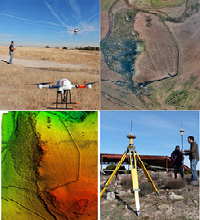
DRON MD4-1000 and GPS TOPCON GR-5. Photogrammetry and Digital Elevation Model at the Llerena site (Badajoz).
Drone. The Drone or UAV is designed to perform field tasks such as documentation, coordination, exploration, prospecting, communication, inspection and observation. It stands out for its great capacity of load allowing to mount professional cameras for FULL HD recording. Other outstanding aspects of this equipment is its wide autonomy as well as the possibility to fly in adverse atmospheric conditions. With a weight of 4,3 Kg, it can transport up to 1,2 Kg. Its flight range is 50 minutes and the activity temperature is between -20º and + 45ºC, with a maximum flight height of 500m. Its modes of flight are RC, GPS and Waypoints and it supports winds of up to 10-13m/s.
Up to now, it has been used in archaeological documentation using videos, orthophotos and digital elevation models, as well as in the environmental study of erosive processes when equipped with the multispectral camera.

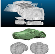
Faro Scanner on the Church of Santiago at Sigüenza. Structured light scanner applied to an Iberian limestone sculpture and a fossil trilobites.
GNSS system (Global Positioning System). These navigation systems are based on radio-frequency satellites, which provide a space-time frame of reference with global coverage continuously anywhere on Earth, and available for any number of users. Our base is a GPS differential model TOPCON GR-5, connected to the satellite network of this Company. This equipment has a mobile antenna and a fixed antenna that allows to develop the differential correction in real time. It consists of 216 Universal Channels of Tracking and G3 technology (GPS / Glonass /Galileo). It allows to build topographies within a centimetric scale of archaeological sites or places of interest. Likewise, it is used in combination with the Georradar and the Drone to georeferentiate its routes and the reference points of the orthophotographs. It is an instrument of great precision and easy handling.
3D Scanners. The CAI Archeometry has two models. One is a structured light scanner model DAVID SLS2. It allows the scanning of objects of medium and small size with a great precision. It is composed of a LED video projector, camera with lenses and slide rail for the camera. Scans of numerous archaeological objects and collections of fossils have been carried out. These scans offer the possibility of reproducing the objects using a 3D printer with all its details and at the chosen scale. Its work focuses on detailed documentation and reproduction of objects for research and management of collections and museums. There is also a laser scanner for large buildings or structures.
|
Advantages |
The CAI of Archeometry offers a series of combined solutions that affect all the steps corresponding to the activities developed on the Archaeological Heritage: location and documentation of deposits from aerial platforms, application of the 3D Georradar to detect buried structures and 3D scanning of the pieces that Are part of collections and museums. To this end, we offer leading services in obtaining and processing aerial images with conventional and multispectral cameras that allow both the discovery of sites and structures not appreciable at ground level, as well as obtaining orthophotographs and Digital Elevation Models. All this is of vital importance for:
A) The Administration, of which depends all Heritage management and actions, and which, with the application of these technologies, can accumulate quality information about the places that are protected and studied. Likewise, the results obtained have a high social projection, since the visitors of sites and museums will understand the value of the application of new technologies, "seeing" and valuing the buried heritage, favoring its conservation.
B) Projects and research groups, which can document both the places in study and their environments and parts of interest through dron, subterranean (surface), surface (topography) and scanning of 3D objects.
C) Private companies of archeology and civil works, which need a knowledge of the places under study and especially of buried structures, to guide their further excavations, repairs, etc.
|
Where has it been developed |
The different technologies of the CAI of Archaeometry have been applied to several archaeological sites with considerable success. Research Projects, Administration and Private Archeology Companies have recently made use of it on different archaeological contexts.
|
And also |
The team of the CAI of Archeometry of the Complutense University works within the usual parameters of Research. The application of its equipments is carried out from a strict knowledge of its operation and possibilities, keeping always up to date the best standars in the development of the equipment and offering a thorough evaluation of the results. Although time is a factor to be taken into account and a maximum speed at work is sought, this never affect the product delivered to researchers and other clients. Also, every work carries a realistic prior assessment, which ensures the viability of the use of the tools, ruling out the orders that cannot be satisfactorily satisfied. Knowledge, training and professionalism are characteristics that make our work exceed the commercial standards in use, providing the maximum guarantee in terms of results.
|
Contact |
|
© Office for the Transfer of Research Results – UCM |
|
PDF Downloads |
|
Classification |
|
Responsible Researcher |
José Yravedra Sainz de los Terreros: jyravedr@ghis.ucm.es
Department: Prehistory, Ancient History and Archeology
Faculty: Geography and History


